Sampling
- Monthly (September 2012 - August 2013)
During the monthly sampling, measurements of the level and the flow of the river are taken, in 4 different locations at the river system. These 4 locations are: the Bridge of Larisa (Alkazar Park), Bridge of Gonnoi, Bridge of St. Paraskevi at Tempi and Palaiopyrgos Bridge. At these 4 points and at the dam at Rapsani, water samples are taken that are afterwards analysed from RT3 of Environmental Chemistry (UOA). Measurements of the water level at pre-specified drills at the deltaic plain are also taken. During the datasampling of May 2013, RT2 did geophysical measurements.
- Every 3 months (October 2012, January 2013, April 2013, July 2013)
During these 3monthly fieldworks, besides the regular monthly measurements, the following are also done: GPS routing of the coastal zone, coastal surveys at pre-defined locations of the coastal zone of the delta. Moreover, phasmatophotometrical measurements of the retro-reflectivity of sediments at already chosen locations are done. Water samples are taken, via a boat at several places of the river, from drills and other chosen points.
- Constant in situ measurements: 2 weather stations have been installed at Palaiopyrgos and Stomio, as well as 2 water level instruments at Palaiopurgos bridge and Pinios’ river mouth.
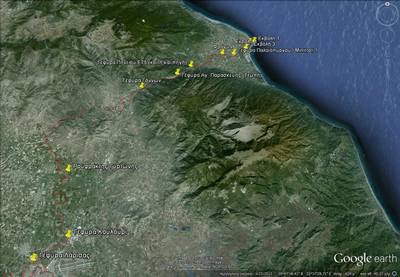
Figure 1: Locations of sampling at the River System of Pinios
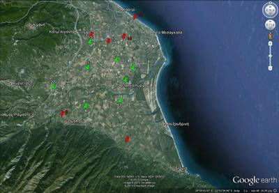
Figure 2: Locations of Drills at the Deltaic Plain of Pinios River.
Data Analysis
Data collected from the fieldwork are analysed with the following methods:
- Sediment samples (marine and land): grain analysis using sieves and phasmatophotometry.
- Water samples: chemical analysis includes quantifying the elements in the samples, the definition of their physical characteristics such as salinity, density etc.
- Statistical analysis of in situ measurements of the flow of the river, the change of its level and the timeseries of the meteorological parameters.
- Routing the coastal line of the delta via GIS.
- Comparing the seasonal topographical surveys that are done perpendicularly at the coastal line at pre-specified locations at the coastal front of the delta.
- Qualitative analysis and elaboration of the data from geoelectrical surveys at the deltaic plain.
- Statistical analysis of the level of chosen drills that will be ultimately used to establish and develop the hydrological model that will explain the river’s system.